Google Earth
Google Earth - This is included as part of the online suite of productivity and digital resources from Google such as word processing, spreadsheets, presentation tools, and graphic organizers. Google Earth lets you fly anywhere on Earth to view satellite imagery, maps, terrain, 3D buildings, from galaxies in outer space to the canyons of the ocean. This does require an outside App or Download. (Approved Site from AUP) Terms | Privacy
You can find this complete list of tutorials for educators at this link. If you are brand new and want to start with the basics... try this tutorial below.
Step 1. Exploration Time (15 minutes)
Take a look at the image below and get to know some of the different areas inside Google Earth. You may wish to open Google Earth to do this. You can have both Google Earth and your browser open at he same time. Click any of the hot links to learn even more.
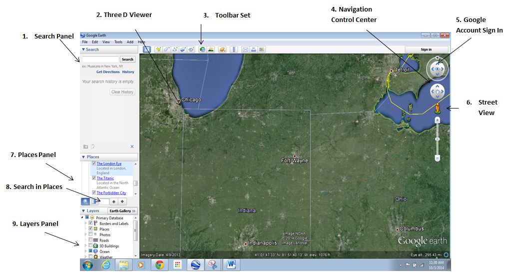
- Search panel - Use this to find places and directions and manage search results. Google Earth EC may display additional tabs here.
- 3D Viewer - View the globe and its terrain in this window.
- Toolbar buttons - See below.
- Navigation controls - Use these to zoom, look and move around. See 'Using the Navigation Controls'.
- Sign in with your Google account - When you sign in, you can share to Google+ or email what you're viewing in Google Earth.
- Street View - Zoom in to the map then drag the pegman to view street-level imagery.
- Places panel - Use this to locate, save, organize and revisit placemarks.
- Search in Places - Find your places quickly by searching for them.
- Layers panel - Use this to display points of interest.
Step 2 - Taking Some First Steps (15 minutes)
Take some time to watch the video. When you are finished open up Google Earth and then take a little time to play and practice. Be ready to share something you learned and think will be useful.
Now that you are finished open up Google Earth and then take a little time to play and practice. Be ready to share something you learned and think will be useful. For the following section of the tutorial it is suggested that you open up Google Earth and practice what you learn
Step 3 Learning About The Tools In Google Earth (20 minutes)
In the area below you will find some important tools that are in Google Earth. Begin to learn about them by working with Google Earth and the tutorials provided below. Many of the hot links bring you more detailed information. Work on your own or with another person.
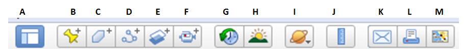
A. Side bar Tool - This tool will hide or the display the side bar on the left hand side of the screen. No tutorial needed.
B. Add Placemark Tool - This tool will add a placemark to Google Earth. Learn how to add one in this placemark tutorial.
C. Add Polygon Tool - This tool allows you to add any polygon and even measure distance, perimeter and sides. Watch this polygon tutorial.
D. Add a Path or Line Tool - This tools allows the addition of a line segment or path. Distances and elevations can be analyzed. Learn in this path (line or lines) tutorial.
E. Add Image Overlay Tool - This tool allows the addition of an image overlay to any Google Earth Map. Take a look at the image overlay tutorial.
F. Record a Tour Tool - This tool allows a recording to be made and saved of a Google Earth Tour. Learn how in the record a tour tutorial.
G. Historical Images Tool - This tool allows the viewing of Google Earth Images as they appear in to the past to the present. Learn more at historical imagery tutorial.
H. Sunlight Tool - This tool allows the viewer to see when the sun will be in that area. View the display sunlight tutorial to learn even more.
I. Sky, Moon, Mars, and Earth Tool - This tools allows some multiple opportunities. Take a look at the sky, moon and planets tutorial.
J. Show Ruler Tour - This tool allows the measurement of a line or path in a multitude of units. Learn more at measure a distance or area size tutorial.
K. Email Tool - This tool allows an image or view to be shared. Learn more on sharing with email in the view tutorial or image tutorial.
L. Print Tool - This tool allows the user to print the current view of the Earth. No tutorial needed.
M. View in Google Maps Tool - This tool opens up a window in browser and displays Google Earth location in Google Maps. No tutorial needed.
Step 4 Classroom Connection Ideas (10 minutes)
Now that you have learned a some Google Earth Basics, begin brainstorming how you might use it in your classroom. Be ready to share with others.